Home of Arizona Brevets and Long Distance Cycling
|
Historic Route 66 REGISTRATION:
Registration is closed or not yet open. |
| The Mother Road |
||||||||
Date: Saturday, May 25, 2013
Distance: 198 miles Start Time: 06:00 Time Limit: 20 hours Sunrise: 5:45 AMSunset: 7:05 PM Cost: $10 Pre-registration is not necessary. RUSA sanctioned. WAIVER NOTE: You will be automatically directed to the online waiver after you submit your PayPal payment. If you are not automatically directed to the online waiver after your pay, you may press the "Return to Merchant" button to sign the waiver. The online waiver may also be found at tinyurl.com/AZBrevetWaiver. REGISTRATION NOTE: Once you are registered for a ride, you will see your name in the Registered Riders tab. It may take a day or so for it to appear. Registered riders WILL be sent a "Last Minute Notes" email the day after registration closes, normally the Thursday before the ride. If you do not receive it, please let me know. Also, check your spam folder for the email. RIDE VERIFICATION: All of these events
are sanctioned by Randonneurs USA (RUSA).
As such, all of them will be verified using approved RUSA
methods. Click HERE
to see the details of available options for AZ Radonneurs'
events. Description
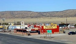
Route is out and back from Chino Valley (north of Prescott) to Peach Springs. After Ash Fork, the route joins I-40 for 5.2 miles out and back. The route travels through Seligman and continues on Route 66 to the turnaround in Peach Springs. Terrain: Flat to rolling. No climbing. Directions to the start Location: Days Inn, Chino Valley Address: 407 S Hwy 89N (mile post 326), Chino Valley, AZ
Route Map
View RWGPS online map here Cue sheets may be downloaded and printed by riders if they wish. Cue sheets will NOT be passed out at the start. Make sure you have a cue sheet as a backup in case your GPS fails. (PDF format is not available.) Elevation Profile One computer app gave it 4,880 feet of climbing. A rider in 2011 measured 6,400 feet. Minimum/Maximum elevation: 4373/5760 feet above sea level
Requirements Lights: Required. There will be a light inspection at check-in to verify front and rear lights are working and are sufficient for night riding. Also required are reflective vest or sash and ankle reflectors. Services 1 Registered Riders.
|