Home of Arizona Brevets and Long Distance Cycling
|
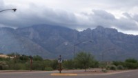
Before Mt Lemmon there's Pusch Ridge as seen from Oro Valley in the early morning. Clouds still envelop Mt Lemmon. (Photo from Bruce Chandler.) REGISTRATION:
Registration is closed. |
| Mt Lemmon Hill Climb |
||||||||||||||||||||||||||||||||||||
Date: Saturday, November 17, 2018
Distance: 125 miles Start Time: 7:00 am Time Limit: 13.5 hours Sunrise: 6:55 amSunset: 5:22 pm Cost: $20 Pre-registration only. No day-of-event registration. RUSA sanctioned. WAIVER NOTE: You will be automatically directed to the online waiver after you submit your PayPal payment. If you are not automatically directed to the online waiver after your pay, you may press the "Return to Merchant" button to sign the waiver. The online waiver may also be found at tinyurl.com/AZBrevetWaiver. REGISTRATION NOTE: Once you are registered for a ride, you will see your name in the Registered Riders tab. It may take a day or so for it to appear. Registered riders WILL be sent a "Last Minute Notes" email the day after registration closes, normally the Thursday before the ride. If you do not receive it, please let me know. Also, check your spam folder for the email. RIDE VERIFICATION: All of these events
are sanctioned by Randonneurs USA (RUSA).
As such, all of them will be verified using approved RUSA
methods. Click HERE
to see the details of available options for AZ Radonneurs'
events. Description
This route travels from Marana (west of I-10), through the urban jungle of Tucson and up Mt Lemmon on Catalana Highway. Turn around is at the top of Mt Lemmon in the town of Summerhaven. Terrain: Flat to rolling for the first 40 miles to the base of the mountain. Then a 25 mile climb to the summit. Return the way you came.FAQ: Mt Lemmon is one big hill - will I make the checkpoints on time?Answer: It's not certain that everyone will make the checkpoints, but things are stacked in your favor. For one thing, the hill climb comes in the middle of the ride. If you ride to the mountain at a moderate speed, you'll have money in the bank. Don't kill yourself getting up the mountain, but don't take long breaks, either. Directions to the start Location: Twin Peaks Rd, Marana Address: Intersection at Twin Peaks Rd and Silverbell Rd, southeast corner Directions: From I-10: Get off I-10 in Marana, at Twin Peaks Rd Exit 244/245. Follow Twin Peaks Rd in a SW direction for 1.7 miles. The brevet start is at the intersection of Twin Peaks Rd and Silverbell Rd, SE corner, where you will see the Safeway store on your left.Google map: Click here
Route Map
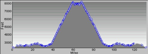
View RWGPS online map here Cue sheets may be downloaded and printed by riders if they wish. Cue sheets will NOT be passed out at the start. Make sure you have a cue sheet as a backup in case your GPS fails. Elevation Profile
About 9,640 feet of climbing. Minimum/maximum elevation: 2291 / 8175 feet above sea level Requirements Lights: Optional. However, if you're still riding after sunset, you need lights as required by law. Services Start: Safeway - 9100 N Silverbell Rd Tucson, AZ 85743 is open on Saturdays at 5am.Mt Lemmon: We're working to get a volunteer with water at Windy Point Vista, but riders should prepare for no water there. Farther up the mountain at Palisades (5 miles from the summit) there MAY (not guaranteed) be water and outdoor toilets. At the summit, there are indoor restrooms and water in the community center which is on your right just as you enter town. There is also a general store in Summerhaven (at the summit) but don't expect anything more than snacks. 8 Registered Riders.
|
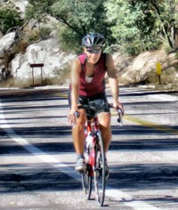 Carol Havrda looking strong and happy on the 25-mile climb on Mt Lemmon. (Photo: Susan Plonsky)