Home of Arizona Brevets and Long Distance Cycling
|
Casa Grande Ruins REGISTRATION:
Registration is closed. |
| Casa Grande Ruins |
||||||||||||||||||||||||||||||||||||||||||||||||||||||||||||||||||||||||||||||||||||||||||||||||||||||||||||||||||||
Date: Saturday, January 12, 2013
Distance: 125 miles Start Time: 7:30 am Time Limit: 13.5 hours Sunrise: 7:30 amSunset: 5:40 pm Cost: $20 All riders must pre-register. (No day of event registration. ACP sanctioned. WAIVER NOTE: You will be automatically directed to the online waiver after you submit your PayPal payment. If you are not automatically directed to the online waiver after your pay, you may press the "Return to Merchant" button to sign the waiver. The online waiver may also be found at tinyurl.com/AZBrevetWaiver. REGISTRATION NOTE: Once you are registered for a ride, you will see your name in the Registered Riders tab. It may take a day or so for it to appear. Registered riders WILL be sent a "Last Minute Notes" email the day after registration closes, normally the Thursday before the ride. If you do not receive it, please let me know. Also, check your spam folder for the email. RIDE VERIFICATION: All of these events
are sanctioned by Randonneurs USA (RUSA).
As such, all of them will be verified using approved RUSA
methods. Click HERE
to see the details of available options for AZ Radonneurs'
events. Description
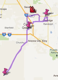
This route is composed of two sections; both sections begin and end in Casa Grande. The first section is a loop that travels north through the Gila River Indian Community with a checkpoint at Casa Grande Ruins National Monument. The second section is out and back and goes south through the Sonoran Desert on the Tohono O'odham reservation. First loop: The route travels north out of Casa Grande and onto SR 387 which is the Gila River Indian Community. This is the only climb on on the ride. (SR 387 has a 3 mile climb, 6% grade) These mountains provide a sanctuary for saguaro and other cactus, making SR 387 one of the prettiest roads around Casa Grande.At the Casa Grande Ruins National Monument, write down on your brevet card the answer to the question posed on the cue sheet. This 40-mile loop ends where it begins - at the Round Trip Bike Shop in Casa Grande. You will have access to your car to shed some clothes and pick up supplies. Second loop: The second section is out and back on Indian 15. It travels south out of Casa Grande and into the Tohono O'odham Indian reservation. This area is mostly undeveloped and composed of rolling hills dotted with sahuaro cactus. The terrain is flat with a few long, rollers. (Total 1,480 feet of accumulated elevation. See elevation profile.) This second loop in particular is very remote. The only services you will find are our checkpoints. Checkpoints are about 40 miles apart. A hydration system such as CamelBak is highly recommended. Directions to the start Location: Round Trip Bike Shop Address: 1148 E. Florence Blvd, Casa Grande, AZ. Click HERE for a Google map of the start location. Lodging in the area: View List
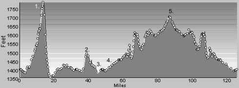
Cue sheets may be downloaded and printed by riders if they wish. Cue sheets will NOT be passed out at the start. Make sure you have a cue sheet as a backup in case your GPS fails. (PDF format is not yet available.) Elevation Profile
1. "Big" hill just north of Casa Grande. 4% grade at most. 2. Woodruff Road, after the college. 3. Back at the Round Trip Bike Shop 4. Entering the reservation. Long rollers after that and nothing I would stand up for. 5. Turnaround and lunch stop.1480 feet of climbing.Minimum/maximum elevation: 1360 / 1786 feet above sea level. Requirements Riders are expected to do simple repairs such as repair a flat tire.Lights: Optional. However, if you're still riding after sunset, you need lights as required by law. Services Mile 0: The bike shop will be open before the ride at checkpoint #1. Bathrooms available. Mile 31: Bathrooms and water are available at the ruins checkpoint #2. Mile 32: Fast food and grocery stores in Coolidge after you leave the ruins. Mile 53: Free snacks and water in the bike shop, checkpoint #3. You will also have access to your car here. You may want to shed some clothes and pick up a hydration system for the southern loop. Mile 88: Free sandwiches, snacks, and soda at the lunch checkpoint #4 on Indian 15. About mile 120: Bob's Market on the left after you leave the reservation. 28 Registered Riders.
|