Date: Saturday, July 13, 2024
Distance: 226 miles
Start Time: 5:00 AM
There will be a mass start at 5 AM and announcements and time for questions at 4:55.
Start Location: Bashas, Flagstaff (Get directions)
Time Limit: 24:16 hours
Sunrise: 5:22 AM
Sunset: 7:423 PM
Cost: $30 All riders must pre-register. There is no day-of-event registration.
RUSA sanctioned.
WAIVER NOTE:
You will be automatically directed to the online waiver after you submit your PayPal payment.
If you are not automatically directed to the online waiver after your pay,
you may press the "Return to Merchant" button to sign the waiver.
The online waiver may also be found at
tinyurl.com/AZBrevetWaiver.
REGISTRATION NOTE: Once you are
registered for a ride, you will see your name in the
Registered Riders tab. It may take a day or so for it to
appear. Registered riders WILL be sent a "Last
Minute Notes" email the day after registration
closes, normally the Thursday before the ride. If you do not
receive it, please let me know. Also, check your spam folder
for the email.
RIDE VERIFICATION: All of these events
are sanctioned by Randonneurs USA (RUSA).
As such, all of them will be verified using approved RUSA
methods. Click HERE
to see the details of available options for AZ Radonneurs'
events.
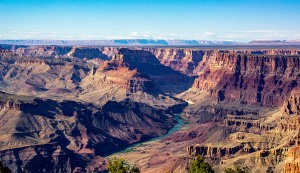
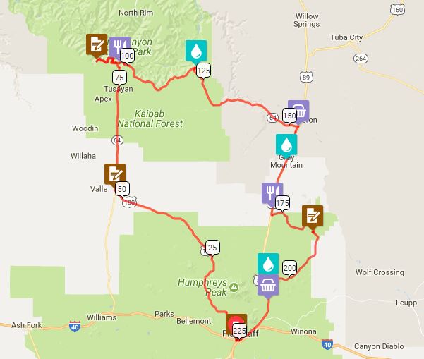
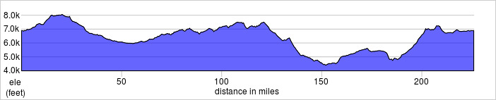
Starting in historic Flagstaff, AZ in the ponderosa pine forest at 7000' (2133m), you'll make your way northwest to one of the seven Natural Wonders of the World, the Grand Canyon. Along the way, you traverse an aspen forest at over 8000' (2438m) before a long and satisfying descent to Grand Canyon Jct and your first control. Get your cameras ready. At this junction is the Flintstones's Bedrock City. Yabba Dabba Doo!
From GC jct, it's a gradual climb to reach the Canyon. After the entrance station, you will first encounter Grand Canyon Village with spectacular views of Bright Angel Lodge, El Tovar Hotel, Grand Canyon Railway and, of course, The Canyon. It's worth a quick stop for photos here. Immediately west of the Village is Hermit Rd (West Rim Drive) which goes along the edge of the Canyon on its "west rim." It will be closed to cars in the summer months. This is the perfect way to see multiple Canyon overlooks on your way to your control at Hermit's Rest. There's a small snack bar there and a viewing area that is perfect for eating your ice cream while gazing at an unbelievable view of the Grand Canyon.
After your stop, you'll return on Hermit Rd to GC Village, making your way toward South Rim Drive. Just before exiting the Village, there's a market & deli that you will want to take advantage of. It will be a long way until your next food stop. Your ride along South Rim Dr will have you rolling between 7000'-7500' (2133m-2268m) to your final views of the Canyon at Desert View Overlook where you will see the iconic Watchtower. Make sure you gaze into the Canyon here. Some of the best views of the Colorado River are from this vantage point. Alas, it will be time to push on.
There will be a 3000' (914m) descent from Desert View to the city of Cameron. Keep your cameras handy, though. There are some spectacular views of the Little Colorado River Gorge and its many crevices carved into the Kaibab Plateau. It will heat up as you descend. Cameron will be a welcome respite and time to recover and refuel for the long climb ahead. The next 20 miles will have you climbing to the turn which will take you to your next adventure loop - Wupatki National Monument (NM) and Sunset Crater Volcano National Monument. It will be a quick, pleasantly car-free downhill to your control at Wupatki NM Visitor Center. If you have the interest, there are numerous ruins along this route with access right off the road. Pre planning will help you choose which to stop at and which might be too far off road. After the Wupatki control, you will start your 2000' (610m) climb up to Sunset Crater Volcano and its Lava Fields. Shortly after the Sunset Crater Visitors Center, you'll be back into reality and start your rolling descent back into Flagstaff.
This is a big ride in many ways. At 226 miles (364km) and 11,000' (3350m) of climbing, it's a big effort to complete. Even bigger, though, is the magnitude of the awe you get to experience while riding.
Check out the Photo Album
Location: Bashas, Flagstaff
Address: Bashas' 2700 S Woodlands Village Blvd
Flagstaff, AZ 86001
Phone: +1 928.774.3882
Google map:Click HERE
Directions: Just off the I-17 exit in Flagstaff
View RWGPS online map here
Cue sheets may be downloaded and printed by riders if they wish. Cue sheets will NOT be passed out at the start. Make sure you have a cue sheet as a backup in case your GPS fails.
Download cue sheet (xls)
Download cue sheet (pdf)
Total elevation gain for the 360k is ~11,000 feet.
Lights: Required. There will be a light inspection at check-in to verify front and rear lights are working and are sufficient for night riding. Also required are reflective vest or sash and ankle reflectors.
Regular services are available for the first 160 miles. The next 60 miles will have sparse services. Water should be available regularly, but food, not as much. If the temperatures are hot, you may find that a 3rd water bottle or hydration pack will be your friend. Riders should plan accordingly!
This event will not be supported. Riders need to know their own abilities and get food and water where available. If you abandon the ride, you will need to find your own way back to the start.
July is monsoon season in Arizona's high country. It is not uncommon to have evening rain. It's usually refreshing, but can be cold at these elevations. Riders should be prepared accordingly.
| Rider Name |
RUSA # |
City |
State/Prov |
| Mike Sturgill |
1847 |
Phoenix |
AZ |
| Wei Sun |
9917 |
San Diego |
CA |