Home of Arizona Brevets and Long Distance Cycling
|
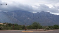
Before Mt Lemmon there's Pusch Ridge as seen from Oro Valley in the early morning. Clouds still envelop Mt Lemmon. (Photo from Bruce Chandler.) REGISTRATION:
Registration is closed or not yet open. |
| Mt Lemmon 100k |
||||||||||||
Date: Saturday, November 15, 2014
Distance: 62 miles Start Time: 09:00 Time Limit: 7 hours Sunrise: 6:50 amSunset: 5:25 pm Cost: $20 Pre-registration only. No day-of-event registration. RUSA sanctioned. WAIVER NOTE: You will be automatically directed to the online waiver after you submit your PayPal payment. If you are not automatically directed to the online waiver after your pay, you may press the "Return to Merchant" button to sign the waiver. The online waiver may also be found at tinyurl.com/AZBrevetWaiver. REGISTRATION NOTE: Once you are registered for a ride, you will see your name in the Registered Riders tab. It may take a day or so for it to appear. Registered riders WILL be sent a "Last Minute Notes" email the day after registration closes, normally the Thursday before the ride. If you do not receive it, please let me know. Also, check your spam folder for the email. RIDE VERIFICATION: All of these events
are sanctioned by Randonneurs USA (RUSA).
As such, all of them will be verified using approved RUSA
methods. Click HERE
to see the details of available options for AZ Radonneurs'
events. Description
This route travels from Le Buzz Coffee (a popular hang out for Mt. Lemmon Cyclists) up Mt Lemmon on Catalana Highway. Turn around is at the top of Mt Lemmon in the town of Summerhaven.
Terrain: Flat to rolling for the first few miles to the base of the mountain. Then a 25 mile climb to the summit. Return the back way along Soldier Trail and Tanque Verde.
Directions to the start Location: Mt. Lemmon Highway, Tucson Address: Intersection at Mt. Lemmon Highway and Tanque Verde Directions: From I-10: Get off I-10 in Tucson at Grant Rd Exit 256. Follow Grant Rd East until it ends at Tanque Verde. Turn left on Tanque Verde Rd. Follow Tanque Verde Rd unitl you reach Mt. Lemmon Highway. The brevet start is at the intersection of Mt. Lemmon Highway and Tanque Verde, NE corner. The shopping center includes Safeway and Le Buzz Coffee.Google map: Click here
Route Map
View RWGPS online map here Cue sheets may be downloaded and printed by riders if they wish. Cue sheets will NOT be passed out at the start. Make sure you have a cue sheet as a backup in case your GPS fails. (PDF format is not available.) Elevation Profile
About 6,800 feet of climbing. Minimum/maximum elevation: 2500 / 8175 feet above sea level Requirements Lights: Optional. However, if you're still riding after sunset, you need lights as required by law. Services Start: Safeway – 9125 E Tanque Verde Rd Tucson, AZ 85749 is open on Saturdays at 5am.
2 Registered Riders.
|
