Date: Sunday, July 14, 2024
Distance: 148 miles
Start Time: 6:00 AM
There will be a mass start at 6 AM and announcements and time for questions at 5:50.
Start Location: Bashas, Flagstaff (Get directions)
Time Limit: 15:50 hours
Sunrise: 5:23 a.m.
Sunset: 7:41 p.m.
Cost: $25
All riders must pre-register. There is no day-of-event registration.
RUSA sanctioned.
WAIVER NOTE:
You will be automatically directed to the online waiver after you submit your PayPal payment.
If you are not automatically directed to the online waiver after your pay,
you may press the "Return to Merchant" button to sign the waiver.
The online waiver may also be found at
tinyurl.com/AZBrevetWaiver.
REGISTRATION NOTE: Once you are
registered for a ride, you will see your name in the
Registered Riders tab. It may take a day or so for it to
appear. Registered riders WILL be sent a "Last
Minute Notes" email the day after registration
closes, normally the Thursday before the ride. If you do not
receive it, please let me know. Also, check your spam folder
for the email.
RIDE VERIFICATION: All of these events
are sanctioned by Randonneurs USA (RUSA).
As such, all of them will be verified using approved RUSA
methods. Click HERE
to see the details of available options for AZ Radonneurs'
events.
Route is preliminary pending RUSA approval. Start/Finish location will not change.
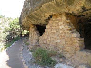
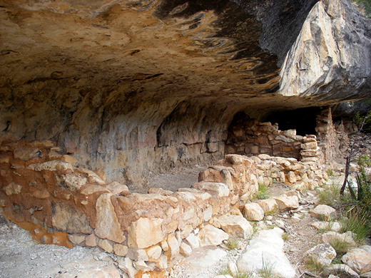
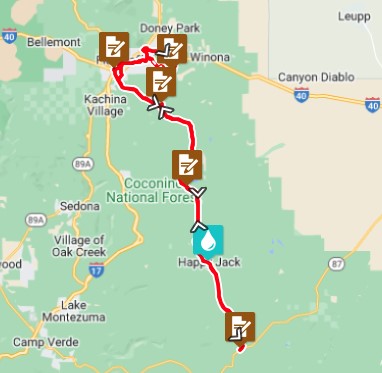
The Coconino National Forest covers 1.9 million acres in Northern Arizona and ranges in elevation from 2600' (800m) to 12,633' (3850m). We won't be able to explore all of it, but this route will whet your whistle imploring you to come back and quench that appetite. We will start our day a couple miles from the Lowell Observatory where Pluto was discovered in 1930. It's 1 of 3 Lowell Observatories in the area. We will be visiting the other two on the route. First, though, we will ride thru Northern AZ University by the Skydome while most students will be on summer break. Our first destination will be Walnut Canyon National Monument (WCNM). We won't have time to visit the ruins and geology, but I highly recommend that you make time to visit while you're here. After your control at WCNM, you will ride 4 miles of Arizona dirt. It should be just enough for you to want to come back and explore nearly endless miles of dirt roads in the high country.
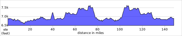
We will make our way back to Lake Mary Rd. This will look like a bicycle highway as it's a favorite route of locals and the desert dwellers coming to Flagstaff to escape the summer heat. We will ride past Lower Lake Mary before we make the turn to the Lowell Observatory Perkins Telescope and the NPOI Telescope. Not familiar with NPOI? Check it out HERE. It's quite unique. After the descent from the telescopes, we'll ride by Upper Lake Mary to our control at Mormon Lake. This will be a good place to grab food it you need it. After Mormon Lake and just before we reach Happy Jack, we will do a Lowell Discovery Telescope "fly-by". This telescope is not open to the public, but is visible as you climb to your high point (7639', 2328m) on today's route. There is a really nice descent after Happy Jack and it's Aspen groves. Your turn around and control will be at Clint's Well. You can refuel here before your trip back to Flagstaff retracing your route.
After riding past Lake Mary, you will head directly back to the start/finish. You will be back early enough to shower and be able to sample some of the local food and brew available to a bustling college town and desert getaway.
This route, alone, will make a fine tour of the areas around Flagstaff. But, if you want the "Grand Tour" of Northern Arizona, you will really want to ride the Grand Canyon 360 as well. The combination of these two routes (Grand Canyon 600) will leave you in awe of the Arizona cycling you don't often hear about.
When you have time to hike!
Location: Bashas, Flagstaff
Address: Bashas' 2700 S Woodlands Village Blvd
Flagstaff, AZ 86001
Phone: +1 928.774.3882
Google map:Click HERE
Directions: Just off the I-17 exit in Flagstaff
View RWGPS online map here
Cue sheets may be downloaded and printed by riders if they wish. Cue sheets will NOT be passed out at the start. Make sure you have a cue sheet as a backup in case your GPS fails.
(Cue sheet is not yet available.)
(PDF format is not yet available.)
Total elevation gain for the 238k is ~6,500 feet.
Lights: We will start in daylight so lights and reflective vest/ankle bands are not required at the start.
But, ALL ARE required if riding after sunset. If you think you might take longer than 12 hours to complete the ride, please take them with you.
Services will be available at regular intervals. 2 water bottles should be sufficient for this ride.
July can bring monsoon rains in Arizona's high country. It is not uncommon to have evening rain. It's usually refreshing, but can be cold at these elevations. Riders should be prepared accordingly.
| Rider Name |
RUSA # |
City |
State/Prov |
| Mike Sturgill |
1847 |
Phoenix |
AZ |