Home of Arizona Brevets and Long Distance Cycling
|
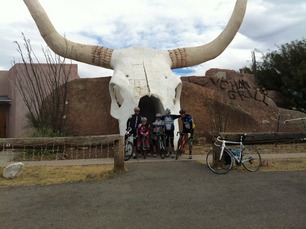
Longhorn Bar and Grill in Amado, AZ. Nice stop location for a photo as you ride. REGISTRATION:
Registration is closed or not yet open. |
| Arivaca 400k |
||||||||||||||||||||||||||||||||||||||||||||||||||||||||||||||||||||||||||||||||||||
Date: Saturday, March 4, 2023
Distance: 250 miles Start Time: 06:00 Time Limit: 27 hours Sunrise: 06:54 AMSunset: 06:27 PM Cost: $30 All riders must pre-register. (No day of event registration.) ACP sanctioned. WAIVER NOTE: You will be automatically directed to the online waiver after you submit your PayPal payment. If you are not automatically directed to the online waiver after your pay, you may press the "Return to Merchant" button to sign the waiver. The online waiver may also be found at tinyurl.com/AZBrevetWaiver. REGISTRATION NOTE: Once you are registered for a ride, you will see your name in the Registered Riders tab. It may take a day or so for it to appear. Registered riders WILL be sent a "Last Minute Notes" email the day after registration closes, normally the Thursday before the ride. If you do not receive it, please let me know. Also, check your spam folder for the email. RIDE VERIFICATION: All of these events
are sanctioned by Randonneurs USA (RUSA).
As such, all of them will be verified using approved RUSA
methods. Click HERE
to see the details of available options for AZ Radonneurs'
events. Description
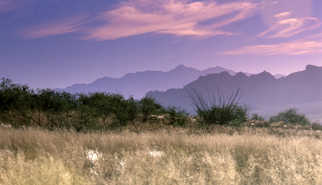
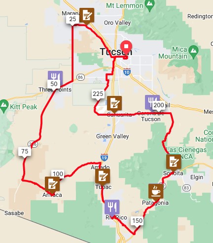
Purple Mountains Majesty over Arivaca This route is large loop predominately south of Tucson. The farthest end of the route comes within a few miles of the Mexican border, just north of Nogales. Terrain: Mostly flat and rolling with a long, steady rise all the way to Arivaca. The area around Arivaca is especially hilly. These short, choppy hills begin on Arivaca Road. After you leave Arivaca, you'll head further south toward Nogales before you turn back north and visit Arizona's wine country in Patagonia and Sonoita. After Sonoita, there's a long and fun descent all the way to Sahuarita. There, you'll meet your last long climb of note. You'll finish by riding through Saguaro National Park in the reverse direction of your morning ride. Directions to the start Location: El Con Plaza Starbucks in Tucson Address: Starbucks at: 3421 E Broadway Blvd #191, Tucson, AZ 85716 Click here for a map to the start. Directions: East on Broadway Rd ~4 miles from I-10There is plenty of parking near Starbucks/Walmart/etc.
Cue sheets may be downloaded and printed by riders if they wish. Cue sheets will NOT be passed out at the start. Make sure you have a cue sheet as a backup in case your GPS fails. Elevation Profile
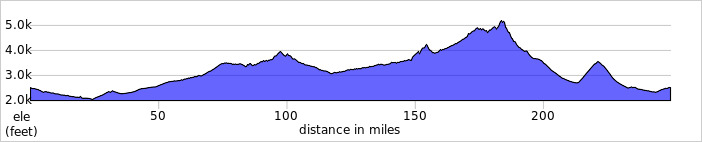
This route climbs roughly 9,000' total feet. All of the climbs are long, gradual and not particularly difficult. Requirements Lights, reflective vest, ankle bands: Required. There will be a light inspection at check-in to verify front and rear lights are working and are sufficient for night riding. Services Services will be noted on the cue sheet and in the RWGPS file, if you choose to download it. 20 Registered Riders.
|