Beware. Sting in the tail!


REGISTRATION:


Registration is closed.


Scorpion 600
600 km Brevet

  • Date/Time
  • Description
  • Directions
  • Route Map
  • Cue Sheet
  • Elevation/Terrain
  • Requirements
  • Rider Info
  • Registered Riders
Date:  Saturday, March 26, 2022

Distance: 374 miles

Start Time: 06:00
There will be a mass start at 6 AM and announcements at 5:55.

Start Location: Courtyard, North Phoenix/Happy Valley (Get directions)

Time Limit: 40 hours

Sunrise:  6:23 AM
Sunset:  6:44 PM

Cost: $20

ACP sanctioned.

WAIVER NOTE: You will be automatically directed to the online waiver after you submit your PayPal payment. If you are not automatically directed to the online waiver after your pay, you may press the "Return to Merchant" button to sign the waiver. The online waiver may also be found at tinyurl.com/AZBrevetWaiver.

REGISTRATION NOTE: Once you are registered for a ride, you will see your name in the Registered Riders tab. It may take a day or so for it to appear. Registered riders WILL be sent a "Last Minute Notes" email the day after registration closes, normally the Thursday before the ride. If you do not receive it, please let me know. Also, check your spam folder for the email.

RIDE VERIFICATION: All of these events are sanctioned by Randonneurs USA (RUSA). As such, all of them will be verified using approved RUSA methods. Click HERE to see the details of available options for AZ Radonneurs' events.

Description


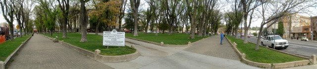
"The Square" in Prescott, AZ

Blow by Blow: We'll start in North Phoenix with a gentle ascent up to Cave Creek to warm up while still in the confines of the city. These are nice roads that will be mostly deserted in the early morning.

After your first control, you will mostly descend for the next 20 miles or so, then head out into the open desert on the Carefree Highway with lots of open miles and no impediments to slow you down. As the sun gradually rises behind you and the desert air warms you up, you'll reach a water/food stop in Wickenburg. You'll want to fuel up here because the climbing is about to start.

Heading out of town will provide some annoying miles getting to the base of the infamous Yarnell Hill. 6 miles at 6% awaits you. The views on the climb are worth the effort. After you reach the town of Yarnell, you'll slowly descend through the ranch lands of the always beautiful Peeples Valley. Look ahead of you to see the White Spar Mountains. You'll switchback your way to the summit at 6200'. Did someone tell you that Arizona is flat?

Next you'll descend into the old west town of Prescott and ride around Prescott Square and Whiskey Row. This is a great place to visit and you have your choice of places to eat on the Square. Take a few minutes and enjoy the Old West here. By now, you'll be ready for some food!

To get back, you'll retrace your route back through Wickenburg, but this time descending White Spar and Yarnell Hill! After Wickenburg, instead of heading across the Carefree Highway you will continue your gradual descent into the far west Phoenix metro area before you turn back east to return to the hotel from which you started.

400 km down and 200 km to go. You can choose to get some sleep and finish the remaining 200k tomorrow morning, or continue to ride straight through. The final 200 km of the route will start by going across the Phoenix Sonoran Preserve and then climbing the lush Sonoran desert of North Scottsdale before descending "9 mile hill." Veteran riders will be familiar with the next section thru Fountain Hills, Bush Hwy/Saguaro Lake but skipping Usery Pass (you're welcome!) After your final control in Mesa, you'll head back thru Fountain Hills and N Scottsdale to your triumphant finish.

Sound interesting? Challenging? Consider joining us on this event. You'll get to see a diverse range of Arizona packed into a challenging couple days.


Directions to the start

Location: Courtyard, North Phoenix/Happy Valley

Address: Courtyard by Marriott, 2029 W Whispering Wind Dr, Phoenix, AZ 85085

Directions:  Take I-17 to Happy Valley Rd. Go EAST and follow the Google map

Google map HERE


Route Map

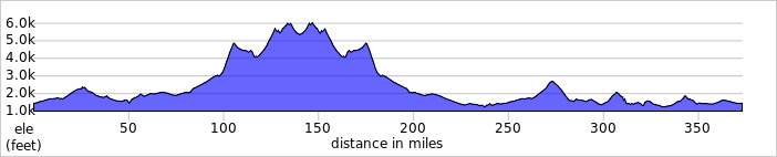
View  RWGPS online map here

The "Scorpion!"
Note that the first 400k is red and the final 200k is blue.


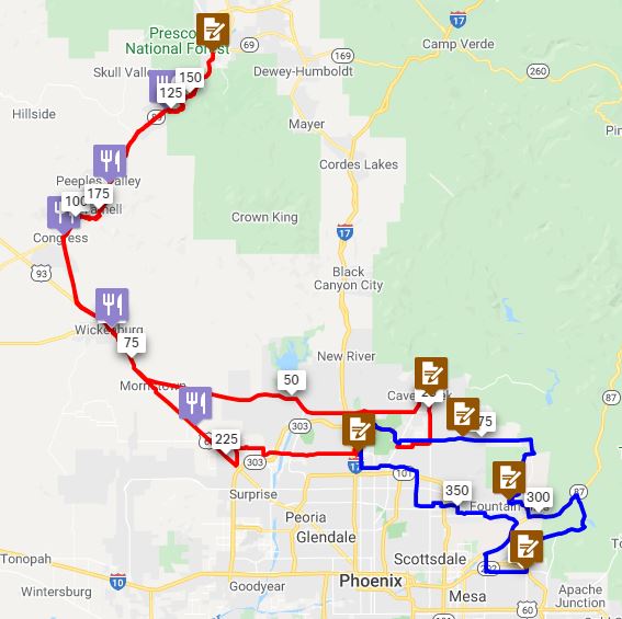
Cue sheets may be downloaded and printed by riders if they wish. Cue sheets will NOT be passed out at the start. Make sure you have a cue sheet as a backup in case your GPS fails.

Download cue sheet (xls)

Download cue sheet (pdf)

Elevation Profile

Approx 16,500 feet of accumulated elevation gain

Minimum/maximum elevation: 1100 / 6200 feet above sea level.


Requirements

Lights: Required. There will be a light inspection at check-in to verify front and rear lights are working and are sufficient for night riding. Also required are reflective vest or sash and ankle reflectors.

Hydration System: Much of the route is very remote with no services. Check the cue sheet carefully to determine how much water you need to carry to get you to the next water hole.

Services

Services will be listed on route sheet

Numerous services are also shown on the RWGPS map.

5 Registered Riders.

Rider Name RUSA # City State/Prov
Steve Atkins 3359 Tempe AZ
Paul Danhaus 1940 Wausau WI
Nathaniel Faulkner 15240 Edmonton AB
Kevin Nelson 1539 Prescott AZ
Mike Sturgill 1847 Phoenix AZ