Home of Arizona Brevets and Long Distance Cycling
|
Saguaro National Park REGISTRATION:
Registration is closed. |
| Saguaro National Park |
||||||||||||||||||||||||||||||||||||||||||||||||||||||||||||||||||||||||||||||||||||||||||||||||||||||||||||||||||||||||||||
Date: Saturday, February 2, 2019
Distance: 187 miles Start Time: 6:00 am Time Limit: 20 hours Sunrise: 7:21 amSunset: 6:00 pm Moonrise: 5:54 AM Cost: $30 All riders must pre-register. (No day of event registration.) ACP sanctioned. WAIVER NOTE: You will be automatically directed to the online waiver after you submit your PayPal payment. If you are not automatically directed to the online waiver after your pay, you may press the "Return to Merchant" button to sign the waiver. The online waiver may also be found at tinyurl.com/AZBrevetWaiver. REGISTRATION NOTE: Once you are registered for a ride, you will see your name in the Registered Riders tab. It may take a day or so for it to appear. Registered riders WILL be sent a "Last Minute Notes" email the day after registration closes, normally the Thursday before the ride. If you do not receive it, please let me know. Also, check your spam folder for the email. RIDE VERIFICATION: All of these events
are sanctioned by Randonneurs USA (RUSA).
As such, all of them will be verified using approved RUSA
methods. Click HERE
to see the details of available options for AZ Radonneurs'
events. Description
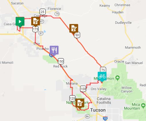
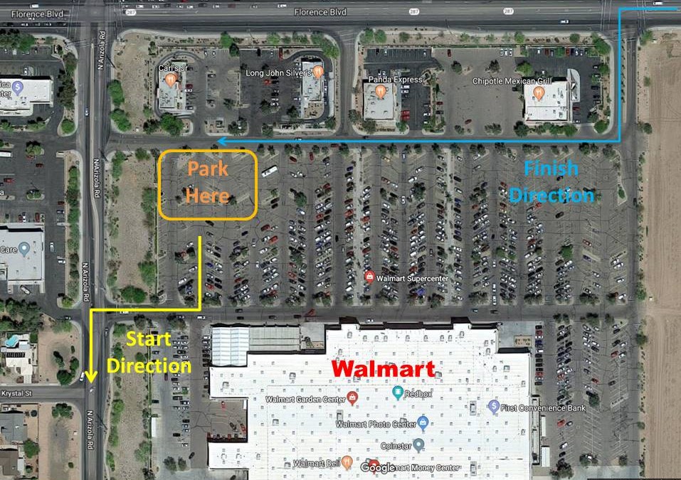
Starting in Casa Grande, the route passes through the cotton fields of Coolidge before heading south on SR 79 (Pinal Parkway) which is designated as a scenic highway. Just before Tucson in Oro Valley we turn west and take Tangerine. On the west side of Tucson, we climb up and over Gates Pass (the easy way) and into Saguaro National Park. The route returns north again through the agricultural town of Marana and passes in the shadow of Picacho Peak before returning to Casa Grande. Terrain: Flat for the first 30 miles through Casa Grande and Coolidge, then a slight, steady but very long climb on Pinal Parkway (SR79). Once you get off Pinal Parkway, (mile 68) it's a long downhill into Tucson. The only other obstacle is the steep climb up Gates Pass and the screaming descent on the other side. There are a few choppy hills through Saguaro National Park. The last 60 miles are flat and travel through the fields of Marana, past Picacho Peak, and finally back to Casa Grande. Total ~4300 feet of climbing. Directions to the start Location: Walmart, Casa Grande Address: 1741 E Florence Blvd, Casa Grande, AZ 85122 GPS coordinates: 32.877369, -111.712218 32 deg 52 min45 sec N, 111 deg 42 min 42 sec W Directions: WalMart parking lot at the north end between Chipotle/Aspen Dental and Panda Express/Game StopClick here for a Google map.
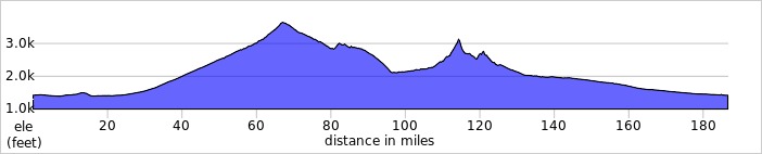
Cue sheets may be downloaded and printed by riders if they wish. Cue sheets will NOT be passed out at the start. Make sure you have a cue sheet as a backup in case your GPS fails. Elevation Profile
You'll find 2 climbs of note. The first is the LONG, gradual ascent on Pinal Parkway. The 2nd is on Gates Pass. We do climb Gates the "easy" way. Total elevation gain is a modest 4300'. Requirements Lights: Required. There will be a light inspection at check-in to verify front and rear lights are working and are sufficient for night riding. Also required are reflective vest or sash and ankle reflectors. Services 30 Registered Riders.
|